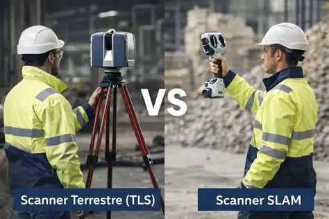
You need a 3D model of a 12,000-square-meter warehouse floor — every column grid, every overhead pipe rack, every mezzanine step. Two survey teams quote the job. One proposes a terrestrial laser scanner on a tripod, 180 setups over three days, each setup capturing a dome of points at 2 million points per second with millimeter accuracy. The other pulls out a handheld SLAM scanner, walks the floor in four hours, and delivers a registered point cloud before dinner — at 2 to 5 centimeter accuracy. Same building, same deliverable format, two fundamentally different answers to the question: how accurate is accurate enough? This article compares the two technologies across accuracy, coverage, workflow speed, and indoor-specific challenges so you can match the tool to the survey requirement, not the sales pitch.
How Terrestrial Laser Scanning Builds a Point Cloud
A terrestrial laser scanner (TLS) is a tripod-mounted instrument that measures the distance to every surface within its field of view using time-of-flight or phase-shift laser ranging. A rotating mirror sweeps the laser beam vertically while the base rotates horizontally, capturing a spherical dome of up to 2 million points per second. Each point carries XYZ coordinates, intensity (return signal strength), and optionally RGB color from an onboard camera. The result from one setup is a single, georeferenced point cloud accurate to ±2–6 mm at 10 meters — but only of what the scanner can see from that one position.
To cover a full building, the scanner moves from setup to setup. At each position, it captures a new dome. Adjacent setups must overlap by 30–40% so registration targets — spheres, checkerboards, or cloud-to-cloud algorithms — can align the scans in post-processing. A 12,000-square-meter warehouse might need 100 to 200 setups. Each setup takes 2 to 6 minutes for the scan itself plus the time to walk to the next position, level the tripod, and place targets. The field work is methodical, the output is precise, and the labor is front-loaded.
How SLAM Handheld Scanning Works
SLAM — Simultaneous Localization and Mapping — is the same principle that lets a robot vacuum navigate a living room without a pre-loaded floor plan. A handheld SLAM scanner carries a laser scanner and an inertial measurement unit (IMU) inside a single device the operator holds while walking. The laser captures the geometry of the surrounding space at 300,000 to 600,000 points per second. The IMU — accelerometers and gyroscopes — tracks the scanner's position and orientation at 200 Hz. The SLAM algorithm fuses the two data streams in real time: the laser tells the system what the environment looks like, and the IMU tells it where the scanner is in that environment. The result is a registered point cloud built continuously as the operator moves — no tripods, no targets, no registration step in post-processing.
The trade-off is baked into the physics. A tripod-mounted TLS measures from a fixed, stable reference — the tripod does not move, so every point's coordinate is computed from a known origin. A SLAM scanner measures from a platform that is itself moving, and its position estimate drifts over time. The IMU corrects for tilt and translation at short time scales, but small errors accumulate. After 100 meters of walking, drift can reach 2 to 5 centimeters. After 300 meters, it can reach 5 to 10 centimeters unless the operator closes the loop — returning to a previously visited area so the SLAM algorithm recognizes the geometry and snaps the trajectory back into alignment.
What accuracy can I expect from SLAM vs TLS indoors?
A well-registered TLS survey delivers 2–6 mm relative accuracy within a single setup and 5–10 mm across multiple setups when using target-based registration. A SLAM handheld scanner operating in a closed-loop trajectory — where the operator starts and ends at the same point — typically delivers 1–3 cm relative accuracy in indoor environments with good geometric features. Without loop closure, drift can push accuracy to 5–10 cm over a 200-meter walk. For floor flatness analysis requiring sub-millimeter precision, TLS is non-negotiable. For generating a 3D BIM model of existing structural steel and pipe routing, SLAM accuracy is sufficient — a 2 cm error on a column location is within the tolerance of most as-built modeling workflows.
Coverage: What Each Technology Misses
A terrestrial laser scanner sees everything in line of sight from the tripod position — but nothing behind a column, under a desk, above a suspended ceiling, or inside a cable tray. Each shadow zone requires an additional setup to fill. In a congested industrial facility, the number of setups is driven less by total floor area and more by occlusion density: how many objects block the scanner's view. A 500-square-meter mechanical room can require more setups than a 5,000-square-meter open warehouse because every pump skid, pipe rack, and cable tray casts a shadow.
A SLAM handheld scanner solves occlusion by moving. The operator walks around columns, ducks under pipes, and holds the scanner into confined spaces. The point cloud is built from thousands of viewpoints along a continuous trajectory, so shadow zones are rare. But the scanner only captures what the operator points it at — a ceiling cavity the operator never looks up at remains unscanned. TLS, by design, captures the ceiling in every setup because the dome is spherical. For overhead features — cable trays, ductwork, sprinkler lines — TLS provides more complete coverage without additional effort.
How long does each method take for a typical indoor survey?
A SLAM handheld survey of a 10,000-square-meter building takes 2 to 4 hours of walking plus 30 to 60 minutes of post-processing for loop closure and point cloud export. A TLS survey of the same building at 5 to 8 mm resolution with standard overlap takes 2 to 3 days of field work — 100 to 180 setups at 4 to 6 minutes each plus walking and leveling time — plus 4 to 8 hours of registration post-processing. The SLAM time advantage is measured in multiples, not percentages, and it grows with building size. But the TLS output is more precise, more complete for overhead features, and more defensible if the survey must withstand contractual accuracy verification.
Which method works better in feature-poor spaces?
SLAM depends on geometric features — corners, edges, surface texture variations — to localize itself. A long, smooth, featureless corridor with uniform walls and no door frames is a SLAM failure mode: with nothing distinctive to lock onto, the IMU drifts and the algorithm cannot correct. A TLS setup in the same corridor has no such dependency — the scanner sits on a known point, measures from a stable position, and does not need to track its own movement. For underground tunnels, long straight pipe galleries, or empty warehouse shells without interior partition walls, TLS is the safer choice. Some high-end SLAM scanners incorporate a secondary sensor — a stereo camera or a 360° panoramic camera — to provide visual features when geometric features are sparse, but the accuracy in these environments still degrades relative to well-featured spaces.
Post-Processing: Registration vs Trajectory Optimization
TLS post-processing is registration: aligning dozens or hundreds of individual scans into a single coordinate system. Target-based registration — using spheres or checkerboards placed in the scene — is the most accurate method but requires placing targets before scanning and manually identifying them in the software afterward. Cloud-to-cloud registration automates the alignment by matching overlapping geometry between adjacent scans, trading some accuracy for reduced field setup time. Either way, registration is the bottleneck that turns three days of scanning into a week of office work before the deliverable is ready.
SLAM post-processing is trajectory optimization. The raw output is a point cloud plus the estimated scanner trajectory. The software runs a global optimization — adjusting the trajectory so that points captured from different positions but representing the same physical surface align as tightly as possible. Loop closure is part of this optimization: when the algorithm detects that the scanner has returned to a previously visited location, it distributes the accumulated drift backward along the trajectory, improving the entire path. The process is largely automated and completes in minutes to an hour, not hours to days.
Decision Framework: When to Choose Which
| Survey Requirement | Best Tool | Reason |
|---|---|---|
| Floor flatness or surface deviation analysis (±1–2 mm) | TLS | SLAM cannot achieve sub-centimeter accuracy at survey scale |
| As-built BIM model of structural steel and MEP routing | SLAM | 2–3 cm accuracy is within BIM tolerances; speed advantage is decisive |
| Heritage documentation requiring photorealistic texture and archive-grade accuracy | TLS | Onboard HDR camera, fixed tripod = no motion blur, ±2 mm = defensible for conservation records |
| Active factory or hospital where tripods obstruct operations | SLAM | Operator moves with foot traffic; no exclusion zones around tripod setups |
| Long featureless tunnels or pipe galleries (>100 m straight runs) | TLS | SLAM drift in feature-poor environments; TLS unaffected by geometry monotony |
| Multi-story building with staircases and narrow rooms | SLAM | Continuous scanning through transitions; TLS setups multiply per room per floor |
| Legal or contractual survey requiring signed accuracy certification | TLS | Total station-verified control points can be integrated; SLAM accuracy is statistical, not verifiable point-by-point |
| Rapid emergency response or disaster assessment | SLAM | Minutes to deploy, no setup logistics, acceptable accuracy for damage quantification |
Can I combine SLAM and TLS in the same project?
Yes — and for complex industrial facilities this is often the optimal approach. Use TLS to establish a georeferenced control network at critical areas: main equipment halls, critical tie-in points, and outdoor-to-indoor transition zones where coordinate accuracy matters for design interfaces. Fill the remaining 70–80% of the facility with SLAM, using the TLS control points as constraints during trajectory optimization. The SLAM output inherits the accuracy of the TLS control network at those points, and the combined point cloud delivers millimeter accuracy where it matters and centimeter accuracy where it is good enough — at roughly half the total field time of a TLS-only survey.
Choosing between SLAM handheld and terrestrial laser scanning is not about which is better — it is about which accuracy class your deliverable requires and how much field time you can afford. If the answer is "millimeter," TLS is the only option. If the answer is "centimeter and fast," SLAM wins by a factor of five to ten on schedule. In a growing number of projects, the right answer is both — TLS for control, SLAM for coverage.